
Rochdale and Littleborough Flood Risk Management Scheme
One of the largest inland flood relief schemes in northern England, the Environment Agency’s Littleborough Flood Risk Management Scheme is an £86 million engineering initiative designed to protect up to 337 residential properties and 185 local businesses from severe flooding risk from the River Roch and its tributaries.
The project is being constructed by marine and civil engineering specialist VolkerStevin on behalf of the Environment Agency, working with numerous partners including Rochdale Borough Council.
The scheme targets a highly reactive, steep catchment area historically devastated by watercourses responding rapidly to intense rainfall, most notably during Storm Eva in 2015. The urbanised river valley has an industrial heritage with a legacy of modified channels, bridges, culverts and weirs which further exacerbate the flooding problem. To manage flows over the next 100 years, the scheme utilises a combination of natural flood management and hard-engineered civil interventions.
The overall scheme includes the construction of an extensive flood water impounding structure and storage reservoir at Gale (Gale West and Gale East) to control over-ground surges, and the erection of new raised concrete flood walls as well as modifying pre-existing infrastructure along the River Roch.
Further works comprise enhancing culverts and bridges across key local streams, including Greenvale Brook, Ealees Brook, and collaboration between the construction team and Network Rail to install a 45-meter pre-cast segmental box culvert directly beneath the TransPennine Manchester-to-Leeds railway line to divert flows from the Greenvale Brook into the flood storage reservoir.
Phase 1A was completed in 2024 and included the demolition and replacement of the 22-meter single-span Riverstone Bridge, localised river channel widening, and raising existing flood defence walls. Final landscape integration and grass seeding was completed in the preceding months.
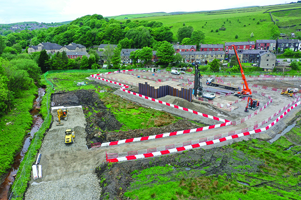
The current Phase 1B (Littleborough) comprises the construction of earth embankments, diversion structures, and sheet piling at Gale East. Works restarted this spring after a planned winter pause.
VolkerStevin and the Environment Agency are prioritising the execution of major earthworks and civil infrastructure across this phase. Operations have resumed at the Gale West and Gale East sites to construct an 80,000m³ flood storage reservoir. Work focuses on importing over 60,000 cubic meters of material to build the massive earth embankments.
As part of the project, VolkerStevin used Atoll’s Drone Management System (ADMS) to ensure that all their drone operations complied with CAA requirements. The simplicity of ADMS means pilots can see they are “Clear to Fly” before quickly completing all the required risk assessments, pre-and-post flight checks and flight logs for their flight operations. VolkerStevin first began using ADMS in the summer of 2025 and value the transparent overview it provides of all flights and the reassurance of a ‘one-click’ audit report for the CAA at audit time.
Following the successful diversion of water flows into newly constructed permanent channels, teams are now infilling the former River Roch channel bed, and construction is also heavily advancing on the main reservoir outlet and flow control structure at the southern end of the site. This structure utilises highly sustainable CIIA-L low-carbon concrete to reduce the project’s overall carbon footprint.
At the same time, piling teams are completing sheet-piled flood walls along the boundary of the TransPennine railway line and Grove Lodge to fully secure the reservoir boundary.
This phase remains on track for an overall construction completion target of early 2027. The downstream urban phase – Phase 2 (Rochdale) – is currently in its initial scoping stage, looking at various options to take forward to its main detailed design study. This phase will feature extensive community engagement once designs advance for proposed flood storage sites upstream of Albert Royds and downstream of Smithy Bridge Road, along with linear defences throughout residential and commercial areas in Rochdale town centre